
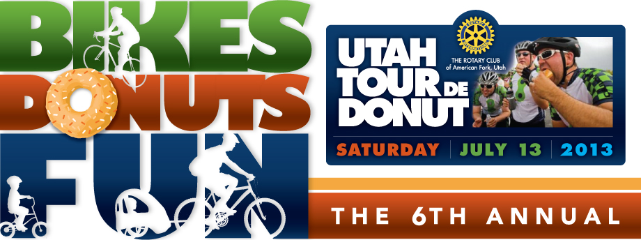
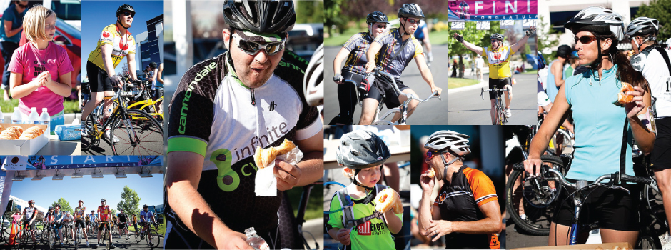
We have photographic evidence

The Utah Tour de Donut sounds like an extraordinary event, right? Well, it is! And here are the photos to prove it!
View PhotosWe love our volunteers!

Volunteers make or break the success of the event for the riders! We anticipate 600 riders this year, so there is plenty to do.
Learn MoreEven donut races have rules

Never ridden in Utah’s craziest race? Well, there’s nothing too it, really! You’ll want to read these tips in preparation for the race!
Educate MeYou wake up at the crack of dawn, lacing up your cycling shoes and pumping up your tires for the big ride ahead. A scenic tour through Utah's countryside awaits, with rolling hills, stunning vistas, and plenty of twists and turns along the way. But this isn't your average cycling event. This is the Tour De Donut, where riders can indulge in sweet treats at donut stops spread throughout the course. You'll need to balance burning calories on those climbs with refueling on fried dough and frosting at each rest stop. The rider who crosses the finish line with the fewest donuts left wins the coveted donut jersey. Are you ready to pedal your way to pastry glory? This whimsical race will test both your legs and your willpower. Let's hit the road!
What Is the Tour De Donut?
The Tour de Donut is a bike ride with a delicious twist - donuts! This annual event, held in the scenic Wasatch Mountains of Utah, features four cycling courses ranging from 15 to 100 miles. Along each route, riders stop at ‘donut stops’ to refuel on the sweet treats. It’s a chance for cyclists of all levels to enjoy Utah’s beautiful scenery while satisfying their sweet tooth.
The Routes
The 15 and 30-mile courses are perfect for casual riders and families. The 60-mile course provides a challenge for intermediate cyclists. For expert riders, the 100-mile ‘Century’ course features over 10,000 feet of climbing through the Wasatch Mountains. At each donut stop, riders receive a stamp in their ‘donut passport’. Collect enough stamps and you’ll earn a prize!
The Donuts
We’re not talking plain glazed donuts here. The Tour de Donut features gourmet donuts from local bakeries, with flavors like apple spice, chocolate peanut butter, and maple bacon. At some stops, live music from local bands helps riders recharge for the miles ahead. Why Ride? The Tour de Donut is a chance to cycle some of Utah’s most scenic byways while enjoying delicious treats along the way. All proceeds from the event benefit local charities like the Muscular Dystrophy Association and the National Ability Center. Riders of all ages and abilities are welcome, so gather your friends and family for a day of cycling, donuts and helping a great cause. There’s simply no tastier way to enjoy the beautiful Utah outdoors!
The History and Origins of the Tour De Donut
The Tour De Donut started back in 1995 as a way to raise money for local charities in Snowbasin, Utah. A few cycling enthusiasts came up with the idea to ride their bikes from bakery to bakery, sampling donuts along the way. It began as a small group of friends, but word quickly spread about this sweet ride.
The First Official Race
In 1996, the first official Tour De Donut race took place. About 50 riders participated, riding a 25-mile loop and stopping at 3 local bakeries for donut tastings. Riders were judged not just on their cycling speed but also on how quickly they could eat 6 donuts at each stop. It was a quirky event that combined Utahns' love of the outdoors, cycling, and, of course, donuts.
Growing Popularity
The Tour De Donut's popularity exploded in the following years. By the early 2000s, the race attracted over 1,000 riders annually. The route expanded to 38 miles, passing by 4-6 bakeries along the way. Categories were added for riders of different skill levels, ages, and bikes. Costumes and donut-themed decorations became an important part of the festivities.
A Sweet Tradition
Today, the Tour De Donut has become a Utah institution. Over 2,500 riders participate each year, with many traveling from out of state. While the race has gotten bigger, it has stayed true to its original purpose: a fun, community-centered event promoting cycling, local businesses, and Utah's beautiful landscapes. After 25 years, it remains a delightfully quirky celebration of Utah's heritage and people.
The Route and Locations for the Tour
The Tour de Donut route winds through some of Utah’s most scenic areas, with pit stops at local donut shops along the way. The ride starts in the town of Hurricane, about 30 minutes outside of Zion National Park. From there, you’ll pedal north on Highway 59, with sweeping views of red rock cliffs and mesas in every direction.
Stop #1: The Donut Wagon in Hurricane
Your first refueling point is at the aptly named Donut Wagon, a retro Airstream trailer turned donut shop. They’re known for creative flavors like maple bacon, cookies and cream, and blueberry lemonade. Grab an assortment to power you through the next 20 miles.
Stop #2: The Donuttery in St. George
In St. George, take a break at The Donuttery, open since 1968. They’re a classic small-town donut shop, where the hot light is always on and a smile comes with every bite of their melt-in-your-mouth treats. The maple bars and buttermilk drops are local favorites.
Stop #3: Riggatti’s Woodfired Pizza in Leeds
For lunch, stop at Riggatti’s in Leeds. They serve up woodfired pizzas, salads, and sandwiches, along with Utah craft beer on tap. Refuel on carbs with a slice of their spicy diavola pizza or a house salad loaded with local ingredients before tackling the climb up Leeds Canyon.
The rest of the route continues north through small towns like Toquerville, La Verkin and Virgin before finishing in Springdale, the gateway to Zion National Park. With each turn of the pedals, the massive sandstone cliffs of Zion get closer until you finally coast into Springdale for the finish line festival in the park. After 60 miles of riding, you’ll have earned every single donut! The Tour de Donut is meant to be challenging but also fun, so take your time, stop for lots of photos, and enjoy all the delicious treats along the way.
What to Expect at the Donut Stops
The Tour de Donut is all about the donuts, after all. At each of the six donut stops along the route, you’ll find an assortment of delicious donuts and refreshments to fuel you for the miles ahead.
The First Stop: Classic Favorites At the first stop, you’ll find all the classic donut shop favorites. Glazed, chocolate frosted, sprinkles, crullers, fritters—if it’s round with a hole in the middle, it’ll be there. Load up on sugar and carbs to power you through the early miles.
Mid-Ride Pick-Me-Up
Around the halfway point, you’ll want something to lift your spirits for the home stretch. Look for more decadent options like maple bacon bars, peanut butter and jelly donuts or lemon-poppy seed donuts. Wash it down with coffee, juice or an energy drink. The sugar rush will make the remaining miles fly by.
The Final Pit Stop
By the last donut stop, you’ve earned the right to indulge. Bite into a red velvet cake donut, or a fluffy buttermilk bar topped with cream cheese icing. For the truly insatiable, there’s always the “Big Kahuna”—a massive homemade doughnut stuffed with custard or fruit filling. After this stop, you’ll coast into the finish, fueled by sugar and the thrill of accomplishment.
While the donut stops are meant to keep you energized, don’t go overboard. Eat in moderation so you can comfortably continue riding and avoid an upset stomach. But do take time to enjoy this tasty reward along the winding roads of Utah. The Tour de Donut only comes once a year, so savor each melt-in-your-mouth moment!
Preparing for the Ride: Training, Gear, and Tips
Training
To prepare for Utah’s Tour de Donut, start cycling regularly in the months leading up to the event. Aim for 2-3 rides per week, starting around 10-15 miles and building up to 25-30 miles. This will get your legs and endurance ready for the 32-mile course. If possible, find routes with some hills to help prepare for the elevation gain. You’ll be glad you put in the time when you’re cruising past the scenic views without feeling winded.Essential Gear
For any long bike ride, having the right gear can make or break your experience. Invest in a comfortable bike seat, padded cycling shorts, a breathable jersey, and cycling gloves. Pack a helmet, tire pump, spare tube, patch kit, multi-tool, snacks, water bottle, and cash in case you want to stop at any of the food vendors along the route. The weather in September can vary, so also bring layers you can add or remove, like a lightweight jacket.Pro Tips
Here are some tips to help you have an enjoyable ride:
- Start slow and pace yourself. It’s not a race, so take time to soak in the scenery.
- Stop at the food stations—you’ll need the energy and the donuts are delicious!
- Ride single file when cars are passing. Be courteous to vehicles and other cyclists.
- Enjoy the downhill portions but be careful. Not all the roads are closed to traffic.
- Take photos! The fall foliage in Utah is stunning. Capture memories of the experience.
- Stick with a buddy. Cycling is always safer and more fun with a friend.
With the proper preparation, equipment, and mindset, Utah’s Tour de Donut can be an incredibly rewarding experience. Follow these tips and you'll be pedaling for pastries in no time! What are you waiting for? Start training and gearing up for a scenic fall cycling adventure in the gorgeous mountains of Utah.
Conclusion
So there you have it. Utah's Tour De Donut is a one-of-a-kind cycling experience that lets you indulge your sweet tooth while getting some exercise. With its beautiful mountain scenery, quirky donut-themed traditions, and small town charm, this ride really captures the flavor of cycling in Utah. You'll work up an appetite as you pedal through gorgeous landscapes. Then you get to refuel at donut stops along the way. Just pace yourself on those pastries if you want to avoid getting a sugar crash! Overall, the Tour De Donut is a tasty way for cyclists of all levels to explore Utah's natural beauty. And you get to end the day with a belly full of donuts - what more could you ask for?